
Ethics and Legality of Remote Sensing from Space and What it Means for Nepal
 |
| Image taken from a 3U CubeSat. Insane. Photo Credits: Planet [HERE] |
Since the launch of Area Surveillance System (SAMOS) in 1961 by the US and then subsequent launch of Kosmos 4 in 1962 by USSR, remote sensing from space has a played an incredibly important role in geo-politics, environment, agriculture, disaster response and mapping. So much so, that scholars believe that it's the reason why the World War was limited to two.
Some scholars have argued that the Cold War years remained essentially peaceful without a war between the superpowers mainly on account of their ability to monitor each others' military installations. This monitoring was carried out using several techniques among which remote sensing was doubtless, the most important.*
*[Overview of Legal Aspects of Remote Sensing,
Journal of the Indian Society of Remote Sensing, Vol.23. No. 3, 1995]
Journal of the Indian Society of Remote Sensing, Vol.23. No. 3, 1995]
The obvious question then would be: is cross boarder observation even legal? What are the ethics behind having a camera point towards earth taking images of sensitive areas globally? What are the laws that prohibit or govern how nations or companies' use sensed data?
A very short answer is YES, it is surprisingly legal. In the Handbook for New Actors in Space 2017 edition, Tanja Masson-Zwaan, the President of International Institute of Space Law writes:
To date, no international treaty governs remote sensing
While no treaty has been signed, there are non binding principles in place that dictates the ethics of use of such data. During the 1986 UN General Assembly, a resolution now called Resolution 41/65 dealing with principles of Remote Sensing was passed unanimously. Out of the fifteen principles, Principle XII is probably the single most important one. It states:
As soon as the primary data and the processed data concerning the territory under its jurisdiction is produced, the sensed State shall have access to them on a non-discriminatory basis and on a reasonable cost terms. The sensed State shall also have access to the available analysed information concerning the territory under its jurisdiction in the possession of any State participating in remote sensing activities on the same basis and terms, taking particularly into account the needs and interests of the developing countries.
What is more surprising is that no prior consent is actually needed from the sensed State by the State or Company that is taking the images. This makes sense if one looks the way developed countries want to have an edge over developing countries with no space systems without having to face any backlash in the future. India's Indian Space Research Organization (ISRO, the "NASA" of India), a strong contender of world's foremost space agencies, can -without any permission from Nepalese Government- take images of Nepal's territory. However, this in an understanding that if Nepal ever needs the data, it has to be provided in a non-discriminatory and reasonable cost terms.
Whose responsibility is then, to monitor and license such a sensitive activity in the first place? According to the paper Overview of the Legal Aspects of Remote Sensing by B.L. Deekshatulu et :
These activities are to be regulated by the concerned state or states and the state is held internationally responsible.
Which basically means it's the sole responsibility of nation where the satellite applies for the remote sensing license. Different countries have different laws governing them but for the case of Nepal, one can look at how India has structured their laws.
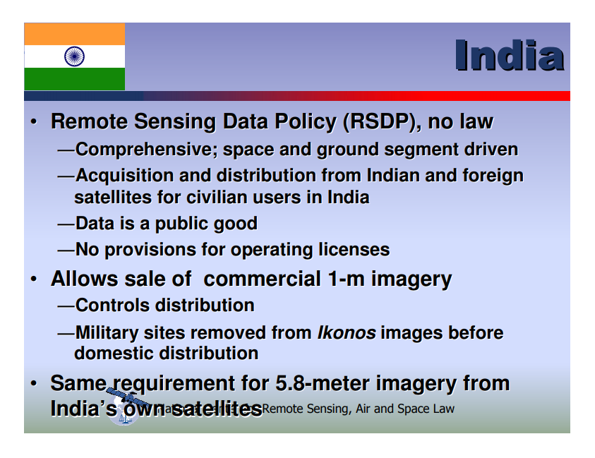 |
| What is striking is that there is policy but no law as of 2010 Ref. [HERE] |
To primarily understand the first sentence, it is important to understand the distinction between policy and law.
Policy: A policy outlines what a government ministry hopes to achieve and the methods and principles it will use to achieve them. It states the goals of the ministry. A policy document is not a law but it will often identify new laws needed to achieve its goals.
Law: Laws set out standards, procedures and principles that must be followed. If a law is not followed, those responsible for breaking them can be prosecuted in court.
[REF. HERE]
A country like India has no provision for remote sensing licensing although it is important to note that all space activities are either governmental (ISRO) or university based (CubeSat standard) which only require amateur frequency allocation or licensing in some special cases through the International Telecommunication Union (ITU). That is however, going to change as private sector is posed to enter market based on a report that was written on November, 2017 [HERE] and remote sensing licensing should, sooner or later, be on the Indian Parliament agenda.
Another important point to note on that presentation slide is the way remote sensed data is distributed. India controls the distribution of images of 1m or less resolution of its territory. In layman terms, this data is blurring the lines between civil and military use and therefore, has been placed under scrutiny. What's so interesting to note in this whole research is that such data is publicly available and can be bought and accessed by anyone.
 |
| NepaliSat-1 is past the Preliminary Design Phase (PDR) |
This brings to the question of NepaliSat-1 and its remote sensing capabilities. Nepal's first satellite is part of the BIRDS-3 Satellite Project along with Sri Lanka's Raavana-1 [HERE] and will have a 5MP camera on board in RGB (Red Green Blue, basically your standard mobile phone camera) spectrum with a ground resolution of 300m. The focal length is severely limited due to volume and downlink constraints and thus will only be taking VGA (640 X 480) images with lower ground resolution such as this one below from ESTCube-1:
 |
| ESTCube-1, Estonia's first satellite's image of Gulf of Mexico Ref. [HERE] |
Verdict:
Given that there's already 1m resolution data publicly available and given the extensive research done on the ethics and legalities, NepaliSat-1 has no problem taking images from space over any territory.


Comments
Post a Comment